
![]() Call us now:
Call us now:
Aerial surveys have played a significant role in the field of surveying and cartography for many years. The origins of capturing images from the sky can be traced back to 1858 when French photographer Gaspard-Felix Tournachon took aerial photographs of Paris using a hot air balloon. In 1882, British meteorologist E.D. Archibald pioneered the concept of unmanned aerial surveying by capturing aerial images with a camera attached to a kite.
The 20th century marked a turning point in using aerial imagery for mapping purposes. Technological advancements allowed for the capture of high-resolution images and videos, which could be stitched together and analyzed using Photogrammetry to extract elevation data. However, the complexity and cost of this technology limited its use to large corporations, entities, and governments. This situation changed with the introduction of more powerful and portable computers, digital photogrammetry techniques, and drone technology. These technological leaps made aerial surveying and mapping accessible to a broader audience at an affordable price.
At Strydom and Associates, we have been conducting our own aerial surveys since 2010 when our founder, Herman Strydom, witnessed the technology on display at a surveying conference in Europe. Our initial drones were locally manufactured in Namibia and served us well for three years before we upgraded to more advanced models to keep up with evolving technology. During this time, we also expanded our aerial survey operations by acquiring manned aircraft, starting with the Jabiru J430 and later adding the Sling 4, both of which allowed us to conduct larger-scale surveys
To effectively meet the diverse needs of our clients, we now possess a range of aerial surveying platforms, including:
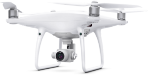
4x DJI Phantom 4 Pro: is a reliable and versatile drone, ideal for small aerial surveys covering areas up to 60 hectares.
Key Features:
- High-resolution camera: Equipped with a high-resolution camera, it captures detailed aerial imagery with exceptional clarity.
- Intelligent flight modes: Offers various intelligent flight modes, such as ActiveTrack and Waypoints, for precise and automated survey missions.
- Obstacle avoidance: Utilizes advanced sensors to detect and avoid obstacles during flight, ensuring safety and smooth operation.
Recommended Use: Ideal for conducting small aerial surveys covering areas up to 60 hectares, making it suitable for applications such as land mapping, construction site monitoring, and agricultural inspections.
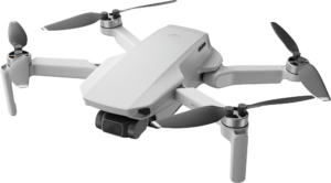
DJI Mavic Air 2 Pro: The DJI Mavic Air 2 Pro is a compact and versatile drone that offers advanced features for aerial surveys.
Key Features:
- High-resolution camera: Equipped with a 48MP camera, it captures detailed aerial imagery.
- Long flight time: With a maximum flight time of up to 34 minutes, it allows for extensive survey coverage.
- Intelligent flight modes: Offers various intelligent flight modes, such as ActiveTrack and Waypoints, for precise and automated survey missions.
- Obstacle avoidance: Utilizes advanced sensors to detect and avoid obstacles during flight, ensuring safety and smooth operation.
Recommended Use: Suitable for medium-scale aerial surveys covering areas up to 100 hectares.
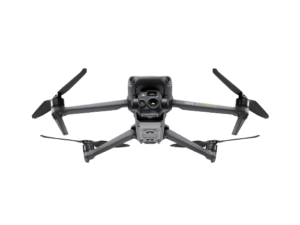
2x DJI Mavic 3: is an advanced drone the offers professional aerial surveying applications.
Key Features:
- Hasselblad camera: Equipped with a high-quality Hasselblad camera, it captures exceptional aerial imagery with a resolution of 20 MP.
- Enhanced flight performance: Offers improved flight stability, agility, and precision, making it suitable for demanding surveying tasks.
- Advanced mapping capabilities: Integrates with mapping software for efficient data collection and analysis.
- Extended range and transmission: Provides an extended control range and stable video transmission, ensuring reliable survey operations.
Recommended Use: Ideal for larger scale aerial surveys covering areas up to 200 hectares.
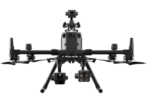
DJI M300 is a professional-grade drone specifically designed for industrial and commercial applications, including land surveying.
Key Features:
- Dual cameras: Features dual cameras for capturing detailed imagery and performing simultaneous visual and thermal inspections.
- Enhanced flight performance: Offers longer flight time, improved stability, and enhanced payload capacity, allowing for more extensive surveys.
- Advanced flight autonomy: Equipped with advanced AI capabilities and obstacle avoidance systems, enabling safe and autonomous survey missions.
- Real-time data transmission: Provides real-time data transmission and live video feed for efficient monitoring and analysis.
Recommended Use: Suitable for large-scale land surveying projects covering areas exceeding 200 hectares.
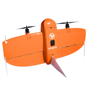
Wingtra ONE VTOL: is a versatile fixed-wing drone designed for conducting aerial surveys.
Key Features:
- Vertical Takeoff and Landing (VTOL): Combines the advantages of both fixed-wing and multirotor drones, allowing for flexible and efficient operations.
- High-resolution camera: Equipped with a high-resolution camera, it captures detailed aerial imagery with exceptional clarity.
- Long flight endurance: Offers extended flight endurance of up to XX minutes, enabling large area coverage in a single flight.
- Advanced flight planning software: Includes advanced flight planning software for precise mission planning and automated survey missions.
Recommended Use: Ideal for conducting aerial surveys of sites ranging from 60 to 1000 hectares, making it suitable for various land surveying applications including topographic mapping, infrastructure planning, and environmental assessments.

Cessna 182 with Fuji GFX100s with a GF50mm F3.5
Description: The Cessna 182 equipped with the Fuji GFX100s and GF50mmF3.5 lens is a specialized aerial surveying setup for high-resolution mapping and detailed inspections.
Key Features:
- Large-format camera: The Fuji GFX100s with GF50mmF3.5 lens offers exceptional image quality and high-resolution mapping capabilities.
- Extended flight range: The Cessna 182 allows for extended flight range and endurance, enabling the coverage of large areas in a single flight.
- Aerial mapping software integration: The imagery captured can be seamlessly integrated with aerial mapping software for precise mapping and analysis.
- Versatile applications: Suitable for various land surveying tasks, including topographic mapping, infrastructure planning, and environmental assessments.
Recommended Use: Ideal for large-scale land surveying projects, particularly those requiring high-resolution imagery and extensive coverage.
These resources ensure that we can deliver comprehensive and tailored surveying services to our valued clients.